Formation of Boulder Field
Boulder Field is a periglacial feature that formed as a direct result of its proximity to the end moraine of the Wisconsin Ice Sheet. This climate was cold enough to create permafrost and expose bedrock, but also warm enough to allow temperatures to climb above freezing point. The end moraine was identified approximately one mile northeast of the current day boulder field, and is comprised of unsorted rock and soil that had built up near the front edge of the ice sheet approximately 20,000 ya. Because of this moraine, Geologists have determined that this is the southernmost point of the ice sheet in northeastern Pennsylvania. Still to the south and west, however is Boulder Field; this is the primary evidence that supports the idea of Boulder Field being a periglacial landform.
Geologists have pieced together this puzzle by understanding that the climate in the direct vicinity of the ice sheet must have been similar to that of the Greenland Ice Cap region today, it has been inferred that the region that Boulder Field occupies must have therefore been of similar climate. Being in such close proximity, the ground undergoes freezing and thawing periods (long winter freezing and drastic thawing in the summer months). The evidence for this can be seen on the ridges to the north and south of boulder field, where apparent mechanical weathering has occurred along those ridges via frost heave. Outcrops in the area contain fractures that have block-like characteristics, where the freeze thaw periods caused the mechanical weathering of the rock. As water seeps into fractures and freezes, rock fragments break off of the outcrop via frost heave. Repeated freeze-thaw periods during glaciation in the region is likely what deposited the large pile of angular blocks at the base of the ridges (Geyer, n.d.).
Along with the angular blocks at the ridge base, there was also likely large amounts of sand, clay, mud, and ice. During each summer thaw, water-laden material on the upper part of the mass was pulled down-slope by gelifluction and deposited the angular blocks. After more repeated freeze thaw cycles, the blocks became much more well-rounded as the blocks would grind against each other while moving down-slope. Evidence of this can be seen in the field, as more well-rounded blocks can be observed along the westernmost edge of Boulder Field; and more angular blocks are common to the east and along the base of ridges (or closer to the source). During the last thaw period and when the climate warmed in the region, movement of the blocks ended (at least from glacial conditions) and remained as it is today – a relatively flat and irregular valley with ridges to the north and south, filled with well-rounded boulders to the west and angular blocks to the east (Geyer, n.d.). The final piece of this formation also occurred during the last thaw, when the ice melted and washed away the finer material (sand and clay) between the boulders and left the open spaces we see today; with less the accumulation of leaves, pine needles, and moss in open spaces.
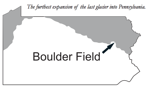
Image via http://www.dcnr.state.pa.us/cs/groups/public/documents/document/dcnr_004626.pdf
Gelifluction and Mechanics
It is important to describe the complexities of the down-slope movement and the mechanics involved in the development of Boulder Field. The down-slope movement of the weathered angular blocks was caused by gelifluction – a process whereby the active layer of permafrost melted, and the mass containing rock, soil, mud, water and sand slid down-slope along the still frozen permafrost below. This downslope was incredibly slight (~ 1 degree), and the speed of movement is unknown. Because of this extremely low angle, repeated cycles, and time, this is likely the reason well-rounded boulders are more abundant to the west – or farther from the parent rock (Hickory Boulder Field, n.d.).
In addition to moving down-slope, the blocks were also moved vertically. This is attributed to the constant formation of ice beneath the blocks heaved them upward, and lifted the boulders. Larger boulders were lifted higher because of their respective geometries (greater surface area). This upward movement further contributed to the grinding of rock, and overall roundness of the blocks. It is, however, unclear how far exactly (if at all) the boulders were transported (Hickory Boulder Field, n.d.). Some have speculated that the rock simply weathered in place are were not susceptible to transport (I disagree with this theory).
In addition to moving down-slope, the blocks were also moved vertically. This is attributed to the constant formation of ice beneath the blocks heaved them upward, and lifted the boulders. Larger boulders were lifted higher because of their respective geometries (greater surface area). This upward movement further contributed to the grinding of rock, and overall roundness of the blocks. It is, however, unclear how far exactly (if at all) the boulders were transported (Hickory Boulder Field, n.d.). Some have speculated that the rock simply weathered in place are were not susceptible to transport (I disagree with this theory).
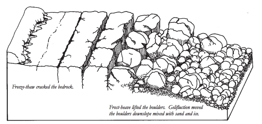
Image via http://www.dcnr.state.pa.us/cs/groups/public/documents/document/dcnr_004626.pdf
Geology
In addition to its irregular geometry described above, Boulder Field features an uneven relief that is highly uneven and can be difficult to traverse. This is attributed to the vast assortment of boulders that occupy the valley and massive size differential of respective boulders. The diameter of the boulders are typically < 4 feet and vary drastically in length from inches to 25 feet; however, most boulders are < 4 feet in diameter and length. The blocks found in Boulder Field likely stem from nearby ridges to the north and south (The Mild, Modern Climate, n.d.). Rocks along theses ridges are sandstones (of the Duncannon Member), siltstones, and conglomerates associated with the upper portion of the Catskill Formation, and are the same type of rock found in Boulder Field – and therefore likely represent the likely source material for Boulder Field.
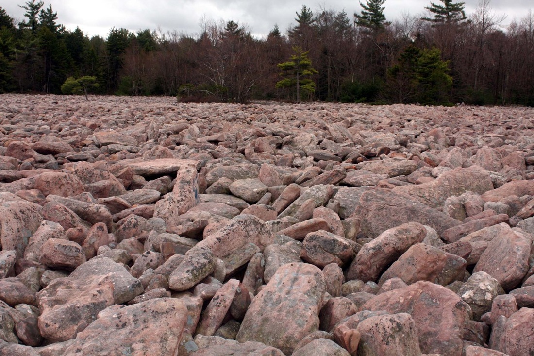
Image via https://hillscloud.wordpress.com/boulder-fields/
